About Florida
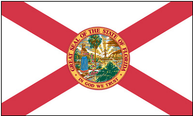
The current design of Florida’s state flag was adopted in 1900. In that year, Florida voters ratified a constitutional amendment based on an 1899 joint resolution of the state legislature to add diagonal red bars, in the form of a St. Andrew’s cross, to the flag.
Between 1868 and 1900, Florida’s state flag consisted of a white field with the state seal in the center. During the late 1890s, Governor Francis P. Fleming suggested that a red cross be added, so that the banner did not appear to be a white flag of truce or surrender when hanging still on a flagpole.
In the rewriting of the Constitution in 1968, the dimensions were dropped and became statutory language. The flag is described in these words: “The seal of the state, of diameter one half the hoist, in the center of a white ground. Red bars in width one fifth the hoist extending from each corner toward the center, to the outer rim of the seal.”
Quick Facts
Geographical facts
• Total Area – 58,560 square miles
• Total land area – 54,136 square miles
• Total water area – 4,424 square miles
• Rank among states in total area – 22nd
• Length north and south – 447 miles (St. Marys River to Key West)
• Width east and west – 361 miles (Atlantic Ocean to Perdido River)
• Distance from Pensacola to Key West – 792 miles (by road)
• Highest Natural Point – 345 feet
• Geographic Center – 12 miles northwest of Brooksville, Hernando County
• Coastline – 1,197 statute miles
• Tidal shoreline (general) – 2,276 statute miles
• Beaches – 663 miles
• Longest River – St. Johns, 273 miles
• Largest Lake – Lake Okeechobee, 700 square miles
• Largest county – Palm Beach, 2,578 square miles
• Smallest county – Union, 245 square miles
• Number of lakes (greater than 10 acres) – about 7,700
• Number of first-magnitude springs – 33
• Number of islands (greater than 10 acres) – about 4,500 Historical facts
• First permanent European settlement – 1565, St. Augustine, by Spain
• Acquired from Spain as a U.S. Territory – 1821
• Admitted as 27th state of the U.S. – March 3, 1845 Current facts
• Capital – Tallahassee
• Population 2020 (estimate) – 20,216,600 (Rank 4th)
• Population 2015 (estimate) – 19,421,200 (Rank 4th)
• Population 2012 (estimate) – 19,074,434 (Rank 4th)
• Population 2010 – 18,801,310 (Rank 4th)
• Population 2000 – 15,982,378
• Population 1990 – 12,937,926
• Population growth rate 2010-2015 (estimate) – 3.3%
• Population growth rate 2000-2010 – 17.6%
• Most populous metropolitan area 2012 – Miami-Ft. Lauderdale-Pompano Beach: 5,657,804 (estimate – Ranked 8th in the US)
• Most populous metropolitan area 2010 – Miami-Ft. Lauderdale-Pompano Beach: 5,564,635
• Most populous County 2020 – Miami-Dade County: 2,722,900 (estimate)
• Most populous County 2015 – Miami-Dade County: 2,600,900 (estimate)
• Most populous County 2010 – Miami-Dade County: 2,496,435 (estimate)
• Number of counties – 67
• Form of government – Governor and cabinet consisting of Attorney General, Chief Financial Officer and Commissioner of Agriculture
• Legislature – 120 house districts, 40 senate districts, 25 congressional districts
Sources:
US Census Bureau
The Florida Handbook, Allen Morris. © 2003.
Florida Statistical Abstract, 2012
ESTA forms Apply here:https://esta.cbp.dhs.gov/esta/
Florida State Flag